Tennessee River
| Tennessee River | |
|---|---|
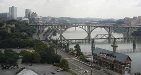 The Tennessee River in downtown Knoxville from the top of Neyland Stadium. |
|
| Origin | Confluence of French Broad and Holston at Knoxville. |
| Mouth | Ohio River at Paducah, Kentucky |
| Basin countries | USA |
| Length | 652 mi (1049 km) [1] |
| Source elevation | 813 ft (248 m) [2] |
| Mouth elevation | 302 ft (92 m) [3] |
| Avg. discharge | 70,575 ft3/s (2,000 m³/s) [4] |
| Basin area | 40,876 mi² (105,870 km²) [4] |
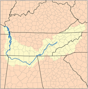
The Tennessee River is the largest tributary of the Ohio River. It is approximately 652 miles (1049 km) long and is located in the southeastern United States in the Tennessee Valley. The river was once popularly known as the Cherokee River, among other names.[1]
Contents |
Course
The Tennessee River is formed at the confluence of the Holston and French Broad Rivers on the east side of Knoxville, Tennessee. From Knoxville, it flows southwest through East Tennessee toward Chattanooga before crossing into Alabama. It loops through northern Alabama and eventually forms a small part of the state's border with Mississippi, before returning to Tennessee. At this point, it defines the boundary between Tennessee's other two Grand Divisions: Middle and West Tennessee. The Tennessee-Tombigbee Waterway, a U.S. Army Corps of Engineers project providing navigation on the Tombigbee River and a link to the Port of Mobile, enters Tennessee near the Tennessee-Alabama-Mississippi boundary. This waterway reduces the navigation distance from Tennessee, north Alabama, and northern Mississippi to the Gulf of Mexico by hundreds of miles. The final part of the Tennessee's run is in Kentucky, where it separates the Jackson Purchase from the rest of the state. It then flows into the Ohio River at Paducah, Kentucky. It is one of a very few rivers in the United States which leave a state and then re-enter it; the Cumberland River is another such river.
Dams
The river has been dammed numerous times, primarily by Tennessee Valley Authority (TVA) projects. The placement of TVA's Kentucky Dam on the Tennessee River and the Corps' Barkley Dam on the Cumberland River directly led to the creation of Land Between the Lakes. A navigation canal located at Grand Rivers, Kentucky links Kentucky Lake and Lake Barkley. The canal allows for a shorter trip for river traffic going from the Tennessee to most of the Ohio River, and for traffic going down the Cumberland River toward the Mississippi.
Important cities and towns
Cities in bold type have more than 30,000 residents
- Bridgeport, Alabama
- Chattanooga, Tennessee
- Cherokee, Alabama
- Clifton, Tennessee
- Crump, Tennessee
- Decatur, Alabama
- Florence, Alabama
- Grand Rivers, Kentucky
- Guntersville, Alabama
- Harrison, Tennessee
- Huntsville, Alabama
- Killen, Alabama
- Kingston, Tennessee
- Knoxville, Tennessee
- Langston, Alabama
- Lenoir City, Tennessee
- Loudon, Tennessee
- New Johnsonville, Tennessee
- Paducah, Kentucky
- Redstone Arsenal, Alabama
- Savannah, Tennessee
- Scottsboro, Alabama
- Sheffield, Alabama
- Soddy-Daisy, Tennessee
- Signal Mountain, Tennessee
- South Pittsburg, Tennessee
- Triana, Alabama
- Waterloo, Alabama
History
Beginning

Officially the Tennessee River begins at mile post 652, where the French Broad River meets the Holston River. According to Tennessee Valley Authority historians, until 1933 the river that flowed past Knoxville was designated the Holston River, and the Tennessee River was considered to begin at the confluence of the Holston and the Little Tennessee River at Lenoir City 51 miles downstream and 601 miles upstream from the Ohio River at Paducah, Kentucky. The nomenclature was changed in 1933 due to a Congressional mandate that the Tennessee Valley Authority headquarters be located on the banks of the Tennessee River. Because the TVA headquarters were to be located in downtown Knoxville, the confluence of the Holston and French Broad Rivers was designated to be the beginning of the Tennessee River, placing the beginning of the river upstream from Knoxville.
Water rights and border dispute with Georgia
At various points since the early 19th century, Georgia has disputed its northern border with Tennessee. In 1796, when Tennessee was admitted to the Union, the border was originally defined by United States Congress as located on the 35th parallel, thereby ensuring that at least a portion of the river would be located within Georgia. As a result of an erroneously conducted survey in 1818 (ratified by the Tennessee legislature, but not Georgia), however, the actual border line was set on the ground approximately one mile south, thus placing the disputed portion of the river entirely in Tennessee.[5][6]
Georgia made several unsuccessful attempts to correct what Georgia felt was an erroneous survey line 'in the 1890s, 1905, 1915, 1922, 1941, 1947 and 1971 to "resolve" the dispute', according to C. Crews Townsend, Joseph McCoin, Robert F. Parsley, Alison Martin and Zachary H. Greene, writing for the Tennessee Bar Journal, a publication of the Tennessee Bar Association, appearing on May 12, 2008.
In 2008, as a result of a serious drought and resulting water shortage, the Georgia General Assembly passed a resolution directing the governor to pursue its claim in the United States Supreme Court.[7][8]
According to a story aired on WTVC-TV in Chattanooga on March 14, 2008, a local attorney familiar with case law on border disputes, says the U.S. Supreme Court generally will maintain the original borders between states and avoid stepping into border disputes, preferring the parties work out their differences.[9]
Meanwhile, many Tennessee lawmakers have dismissed the Georgia claims.
Modern use
The Tennessee River is an important part of the Great Loop, the recreational circumnavigation of Eastern North America by water.
Popular culture
- Cormac McCarthy's 1979 novel Suttree concerns a man who forsakes his life of privilege to become a fisherman along the Tennessee River in Knoxville in the early 1950s.
- The song "Tennessee River" was recorded by the country music band Alabama in 1980.
- Darryl Worley's Tennessee River Run was written and recorded as a memoir to the memories he made over the course of his lifetime on the Tennessee River and at Pickwick Lake, just outside his hometown of Savannah, TN.
Tennessee River tributaries
Tributaries and sub-tributaries are hierarchically listed in order from the mouth of the Tennessee River upstream.
- Horse Creek Savannah, TN (Hardin County, TN)
- Big Sandy River (Tennessee)
- Duck River (Tennessee)
- Buffalo River (Tennessee)
- Piney River (Tennessee)
- Beech River (Tennessee)
- Bear Creek (Alabama, Mississippi) [10]
- Buzzard Roost Creek (Alabama) [10]
- Colbert Creek (Alabama) [10]
- Malone Creek (Alabama) [10]
- Mulberry Creek (Alabama) [10]
- Cane Creek (Alabama) [10]
- Dry Creek (Alabama) [10]
- Little Bear Creek (Alabama) [10]
- Spring Creek (Alabama) [11]
- Cypress Creek (Alabama) [11]
- Shoal Creek (Alabama) [11]
- First Creek (Alabama) [11]
- Elk River (Tennessee, Alabama)
- Flint Creek (Alabama)
- Limestone Creek (Alabama, Tennessee)
- Beaverdam Creek (Alabama)
- Indian Creek (Alabama)
- Barren Fork Creek
- Flint River (Alabama, Tennessee)
- Paint Rock River (Alabama, Tennessee)
- Sequatchie River (Tennessee)
- Chattanooga Creek (Tennessee, Georgia)
- Chickamauga Creek (Tennessee, Georgia)
- Hiwassee River (Tennessee, North Carolina)
- Conasauga Creek (Tennessee)
- Ocoee River (Tennessee, Georgia)
- Nottely River (North Carolina, Georgia)
- Piney River (Tennessee)
- Clinch River (Tennessee, Virginia)
- Emory River (Tennessee)
- Obed River (Tennessee)
- Powell River (Tennessee, Virginia)
- Emory River (Tennessee)
- Little Tennessee River (Tennessee, North Carolina)
- Tellico River (Tennessee)
- Tuckasegee River (North Carolina)
- Nantahala River (North Carolina)
- Cullasaja River (North Carolina)
- Little River (Tennessee)
- French Broad River
- Little Pigeon River (Tennessee)
- Nolichucky River (Tennessee, North Carolina)
- Pigeon River (Tennessee, North Carolina)
- Holston River (Tennessee)
- North Fork Holston River (Tennessee, Virginia)
- South Fork Holston River (Tennessee, Virginia)
- Watauga River (Tennessee, North Carolina)
- Doe River (Tennessee)
- Watauga River (Tennessee, North Carolina)
- Middle Fork Holston River (Virginia)
See also
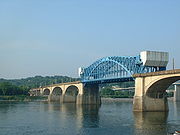
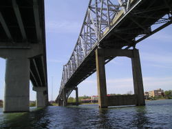
- List of crossings of the Tennessee River
- List of dams and reservoirs of the Tennessee River
- List of Alabama rivers
- List of Kentucky rivers
- List of Mississippi rivers
- List of Tennessee rivers
- Stare decisis
Notes
- ↑ 1.0 1.1 U.S. Geological Survey Geographic Names Information System: Tennessee River
- ↑ U.S. Geological Survey. Shooks Gap quadrangle, Tennessee. 1:24,000. 7.5 Minute Series. Washington D.C.: USGS, 1987.
- ↑ U.S. Geological Survey. Paducah East quadrangle, Kentucky. 1:24,000. 7.5 Minute Series. Washington D.C.: USGS, 1982.
- ↑ 4.0 4.1 "Arthur Benke & Colbert Cushing, "Rivers of North America". Elsevier Academic Press, 2005 ISBN 0-12-088253-1
- ↑ "Georgians thirst to move Tennessee state line". February 8, 2008. http://www.msnbc.msn.com/id/23076509/. Retrieved 2008-05-13.
- ↑ "Desperate for water, Georgia revisits border dispute". February 8, 2008. http://www.cnn.com/2008/US/02/08/drought.state.line.ap/. Retrieved 2008-05-13.
- ↑ Jones, Andrea (February 20, 2008). "Ga.'s quest to move Tenn. border advances". The Atlanta Journal-Constitution. http://www.ajc.com/metro/content/metro/stories/2008/02/20/tennborder_0221.html. Retrieved 2008-05-14.
- ↑ Dewan, Shaila (February 22, 2008). "Georgia Claims a Sliver of the Tennessee River". The New York Times. http://www.nytimes.com/2008/02/22/us/22water.html?em&ex=1203829200&en=9fe2c2ffaf5be75a&ei=5087%0A. Retrieved 2008-05-14.
- ↑ http://www.newschannel9.com/articles/georgia-967199-tennessee-border.html
- ↑ 10.0 10.1 10.2 10.3 10.4 10.5 10.6 10.7 Alabama Department of Transportation (1997). "County Highway Maps" (Lizardtech Plugin). University of Alabama. http://cartweb.geography.ua.edu:9001/StyleServer/calcrgn?cat=North%20America%20and%20United%20States&item=States/Alabama/Counties/colbert/hy_colbert97.sid&wid=500&hei=400&props=item(Name,Description),cat(Name,Description)&style=simple/view.xsl&plugin=true. Retrieved 2007-06-25.
Further reading
- Woodside, M.D. et al. (2004). Water quality in the lower Tennessee River Basin, Tennessee, Alabama, Kentucky, Mississippi, and Georgia, 1999-2001 [U.S. Geological Survey Circular 1233]. Reston, VA: U.S. Department of the Interior, U.S. Geological Survey.
- Myers, Fred (2004). Tennessee River CruiseGuide, 5th Edition
- Hay, Jerry (2010). Tennessee River Guidebook, 1st Edition